CENTRAL EAST VIC:
RECENT OBSERVATIONS
Updated: 4TH / SEPTEMBER /2018
REPORT CONFIDENCE: STRONG
CURRENT UNTIL: 8th / SEPTEMBER/ 2018
OBSERVATION SUMMARY
TREND: IMPROVING / ONGOING / DETERIORATING
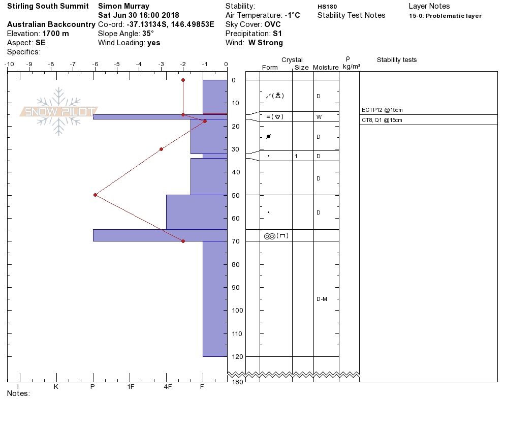
Front Range: Buller / Stirling / BUFFALO
Thanks to the Alpine Access Crew for alerting us to the lapse in updates here. We had issued one last Friday but alas the internets has stolen it? meanwhile:
Patrol Team or Name(s): Luka / Alpine Access
Date: 9/2/2018
Region: Central East Victoria
Specific Location: Stirling Summit
Visibility during Observations: 50m
Known / Observed 'Class One' (Red Flag) instability signs.: Recent rapid rise in temperature to >0˚, Previously observed avalanche (24hrs)
Natural 'Class Two' instability signs.: Shooting Cracks, Indicators of wind loading (drifts / scours)
If you noted any of the above, please provide detail.: cornice collapse debris observed
Recent Deposition: Lee to the North East
Weather Observations: Warming over 0˚(1 Day/Night)
Stability Tests Location: Mt Stirling/1650/south/13:30/22degrees
Standard Compression Test : CT2SC/down5cm/meltfreezecrust
Visible Moisture within snow pack: Yes, under naked eye
Extended Column Test : ECT:P (Propagation occurred)
Rank this hazard by estimation to other observation reports you will be submitting : Primary Hazard
OUTLOOK
Plenty of snow out there, locked into a freeze thaw cycle so watch out for hard shield ice in the early hours on solar aspects and all day on the shady sides. A few warmer temps and some rain will could see a return of the reactive buried crust as a persistent weak layer.
BACK Range: Magdala / Howitt / Viking & Cobbler
We are about to overhaul the entire site given the consistency in field obs between what we will be calling the front and back ranges shortly. For the above areas see below, it will be more relevant.