NORTH EAST VIC:
RECENT OBSERVATIONS
UPDATED: 30TH / JULY /2018
REPORT CONFIDENCE: STRONG
CURRENT UNTIL: 2ND / AUGUST/ 2018
OBSERVATION SUMMARY
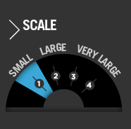
TREND: IMPROVING / ONGOING / DETERIORATING
OBSERVATION:
Funny how some things change, some stay the same. The mercury dropped just below zero yesterday afternoon on the 'wedge' of last nights precip event which made for a nasty breakable crust which we have seen a lot of lately. Then with furious westerlies the precipitation set in so its all dry goodness, sitting on a crust on those aspects lee to the west. The cohesion to the crust is what needs to be seen to be believed. A holding pattern of 'moderate' stability hazard is ongoing (whilst in reality we have dipped in and out over the last week between updates). This time last year we had what was a good cohesive bond between wet old snow and fresh dry cold snow when there was 10cm of it, and then with 40cm+ that bond was overloaded and it let loose. Guess what, there's the potential for 40cm+ plus in the span of the next two updates so get used to this, and 'considerable' by this time next week is possible. We will be up in it and have some good intel by Friday.
OUTLOOK:
There's some big winds and then more snow, following tomorrows mini blizzard that will see the accumulation for 48hrs hit 30cm. Look for yellow flags...
EXTENDED OUTLOOK
There are three big fronts Tuesday, Friday and Sunday. This is Mid winter conditions, and if any of these roll in with 15cm 'On the stakes', then everyone needs to be making smart decisions on terrain choice because, 15cm on the stakes is 40cm on the drift (and more on the cornice), and a 40cm crown wall that propagates 20mx20m is enough to end your day. Stay vigilant folks...
Always a big thanks to everyone who is helping make this possible through our membership kickstart and through our merchandise drive. Simon@MSC

PRIMARY HAZARD
FROM WEDNESDAY 8AM


BECOMING BY WEDNESDAY MORNING


SECONDARY HAZARD
PACK THE PRICKLES


Weather Models
Snowpack Assessments
The schedule for stability assessment reports will be Mondays. Locations are on or above tree-line and generally South East aspect, although this is conditions dependent.
