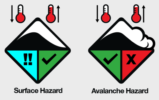
As we transition into spring you will notice that the daily iconography in the Backcountry Conditions Reports has changed from something like this:
to this:
So what does this all mean?
This iconography represents two of the typical hazards you may encounter in spring in the Australian Alps (surface ice hazard and avalanche hazard) and how to think about them.
But before we look more closely at these two hazards, it is important to iterate that the surface ice hazard and the avalanche hazard are not the only considerations for springtime mountain travel. Other hazards continue to warrant your attention, including:
Whiteout conditions: These still exist in the spring so having a good navigation plan for your trip is key should the visibility deteriorate while you are out there.
Severe weather: Cold fronts can still affect the region, and it is advised that you always check the BOM weather forecast before departing on your trip and in particular watch for any severe weather warnings that may affect the region that you intend on travelling.
Creek crossings: You may ford a river in the early morning without much issue only to return to the same river in the afternoon to find the water level too high and fast moving to cross safely.
Cornice development & windlabs: Winter-like storms can still hit the Australian Alps well into the spring. Watch out for new cornice development and wind slabs on the melt freeze crust. Both new cornices and wind slabs are most touchy after they are first formed.
So, that all said, what do these spring condition icons mean?
Surface Hazard
Quite simply, when the temperature decreases (usually in the late afternoon or overnight), the moist/wet snow on the surface from daytime warming refreezes and leaves the surface icy. Then as the day warms up, the icy surface again melts and softens making for good corn skiing. Things to keep in mind are significant weather factors:
Is it cloudy? Things may not soften as quickly.
Is it sunny? Surface will soften quickly on sunny aspects.
Did the temperature go below freezing overnight?
Was it clear overnight? This will lead to hard and icy slopes…
To mitigate risk of falling and sliding on icy slopes, you should have crampons and an ice axe/whippet (and know how to use them), particularly if you intend on being in steep terrain. Also, remember that even changing aspects from a sun-warmed slope to a shady cold slope can be the difference between cruising on corn snow and being gripped on chattery ice.
Avalanche Hazard
This icon represents the variability of avalanche hazard come spring. It can vary from Low to High on any given day. Generally speaking, it is important to reduce your exposure to avalanche terrain when there is strong solar radiation, daytime warming, and/or rain.
In spring, when the surface melt-freeze crust becomes thick and robust (at least 10cm+), it essentially locks up the snowpack. When this is solid and frozen, any deeper layers of concern are typically not affected by the weight and force of a human on top of the snowpack. As such, the risk of triggering an avalanche on a weak layer beneath in these conditions is quite low.
However, when this crust deteriorates due to daytime warming, solar input and/or rain, there is an increased chance of avalanches either on deeper instabilities or in isothermic (one temperature) wet snow. Generally speaking, if you can easily push your ski pole through the snowpack or feel like the snowpack is ‘unsupportive’ or ‘punchy’ (e.g. the backs of your skis are ‘punching’ through and sinking quickly into the snow) then you should move to non-avalanche terrain. The snowpack is cooked for the day and will need the surface melt-freeze crust to refreeze and become thick and supportive again.
Now you may be thinking, damned if I do, damned if I don’t? If it's frozen, I am safe from avalanches but risk icy conditions, and if it is hot and soft I am at risk of avalanches and safe from a sliding hazard on icy slopes? Well… You’re not wrong. The key is timing. The goal is to be on the slope when the surface melt-freeze crust is soft enough, but not unsupportive and deteriorated. Think Goldilocks. “This crust is just right”.
Plan your day, around the sun. East-facing slopes will soften the earliest, followed by the north-facing and then finally the west-facing slopes. If it’s unlikely to be a cold night with a solid refreeze, “alpine starts” may be necessary, where you aim to be at the top of your line before any of the daytime warming even begins.
Spring time can be a fantastic time to get out for some backcountry turns. Days are longer, there can still be good coverage and let’s face it, corn skiing is super fun!
MSC wishes you all a safe spring touring season. We look forward to seeing you out there and serving you next winter with our daily Backcountry Condition Reports come June/July.
For further reading regarding Avalanche hazard and spring conditions, check out the excellent resources at Avalanche Canada.
Happy trails.
Craig Sheppard and Alex Sinickas


