Date: 23/08/2020
Conditions Summary
Sub-alpine: Multiple field teams out yesterday from Dead Horse Gap to Guthega and several places in-between.
Approximately 65cm of storm snow with excellent ski quality (20-30cm of ski penetration). No results from snowpack tests at the storm snow/moist snow interface (down 65cm). Furthermore, instabilities within the storm snow had improved from the previous day are were yielding hard compression test results. The only other signs of instability were small isolated areas of wind slab reactive to ski cutting on lee slopes.
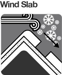
Alpine – No observations – suspect touchy wind slab and cornice development from NW winds.
Alpine Hazards


Sub-Alpine Hazards


Daily Discussion
We are slowly coming out of snowmageddon. Today visibility is forecast to be low, with continued flurries and you can also expect a cold day (apparent temperature -16 currently!). Excellent snow quality in the sub-alpine can be found in sheltered areas.
Be prepared for whiteout navigation and carry an extra layer for the cold conditions.
In the alpine, windslabs are the primary concern. Overnight, the wind has swung around from the NW to W to SW and there is still plenty of snow for transport. Conservative route finding and careful snowpack evaluation are essential.
Beware of cornices. The new cornice development the past few days is likely touchy and may pull back further that you expect.
Confidence: STRONG
Avalanche Problems
Insert Text
Primary Problem
Dangerous avalanche conditions. Careful snowpack evaluation, cautious route-finding and conservative decision-making essential.


Secondary Problem

Evaluate snow and terrain carefully; identify features of concern.


We need your eyes too. If you’ve been in the backcountry we’d love to know what you have seen. Every little bit helps.
Weather Summary
Cloudy. High (80%) chance of snow showers. Winds westerly 20 to 30 km/h becoming light in the late evening. (Source: BOM)