


Region: VIC North East
Spring Conditions
Until next year…
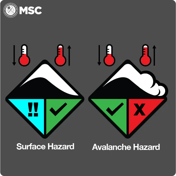
We have finished producing the daily hazard ratings for this season and the hazard rating icons are now replaced with this Spring Conditions icon.
This icon takes into account both the surface ice hazard and avalanche hazard and signifies that conditions are variable on any given day.
The key for safe travel in the spring is timing. If you are too early the surface crust may still be icy and present a sliding hazard, and if you are too late, the crust will have deteriorated and there may be increased avalanche hazard.
Stay safe out there. Have a great spring. We look forward to providing you this service in 2021. Thank you for your support and input this season.

Victorian North East Late September / Avalanche Cycle and season wrap-up
With rain now falling and the dip into sub - zero temps the previous avalanche concern has turned to a ‘spring thing’ with the risk now associated with high daytime temps softening the snow and releasing on the old ‘South and East’ aspect/layer.
We assembled a field obs team off the back of the last storm cycle that produced at least one significant human triggered slide in the Hotham backcountry. The event was consistent with the forecast picture our observations had provided (see archived page here).

Image Credit: Snowsbest.com
So for those with an interest in the detail, Cam, Luka and Simon cut a study profile at the same elevation and aspect to the above crown wall. The storm snow was broken windblown fragments of uncharacteristically low density snow. The temp gradient in the upper layer was -4˚ / -2˚ / -1˚ as 10cm intervals from top to the bed surface. ‘Right-side-up’ in this instance which may have reassured skiers/riders of a low avalanche hazard.
Trick was that three days prior to the storm, a weak front had dropped 2cm / 5cm of wet snow. In the snow profile this layer had been compressed to a 5mm soft wet (4F) ‘sorbet’ like consistency. With warm -0.5˚ spring corn beneath that was not refrozen prior to the ‘sorbet’ event, the ‘sorbet’ stayed warm and provided a slick evening effect on the cupped and course sun effected spring snow beneath.
The new powder snow and the ‘sorbet’ shared a temperature characteristic at -1˚, yet had such starkly different crystal structure that they did not create bond well (‘different size snows won’t hold hands’). Some compression tests showed that 24hrs after the slide, some ‘sorbet’ had bonded to the wind slab, and some to the spring snow. The 5mm ‘sorbet’ layer itself forming the weakness within the snowpack that lead to the avalanche above.
Starkly different crystals, the big crystals on the left wont ‘ hold hands’ with the small crystals on the right. This is the cause of the Avalanche that very nearly took out the skier at Hotham.
Within the storm snow two additional weak layers gave easy results and displayed the potential to propagate. See below.

Science, but not the rocket kind… the wind slab layer is clearly visible above the layer cake of spring snow. The right hand slice shows the full depth on which the avalanche ran. Some of the ‘sorbet’ remnants visible bottom left.
That’s a season wrap for Victoria really. Such a weird season, and here’s to next season when we will be back, better equipped and smarter for the extensive field obs we did perform this year to further progress our understanding of winter snow hazard phenomena here in Australia.
The shovellers! Big Thanks to Craig Sheppard, Luke Szczepanik, Rolf Schonfeld, Cam Walker (honourable mention Drew Jolowicz as ‘wing-man’) and the tireless work of the MSC ‘Board’ and all the volunteer field observers who helped out when the park was open. Thanks to Outdoor Victoria and Parks Victoria for your recognition and support. Regards Simon Murray.


We need your eyes too. If you’ve been touring in the Alpine National Park we’d love to know what you have seen. Every little bit helps.
Weather Summary
Descriptions of weather pattern and what it means with link out to more info Lorem ipsum dolor sit amet, consectetuer adipiscing elit, sed diam nonummy nibh euismod tincidunt ut laoreet dolore magna aliquam erat volutpat. find out more