


Date / Region: 26/09/2020 VicNorthEast
Advisory Confidence: MODERATE
Alpine Conditions


Sub-Alpine Conditions


Mountain environments can be categorised as above or below the tree line, thus Alpine and Subalpine respectively. Find out more about how these types of terrain can create or mitigate backcountry hazards here.
Travel & Terrain advice:
Be aware of navigational issues with low visibility, particularly in the alpine. Avalanche problem developing – wind slab - on slopes lee to the north and west in the alpine, avoid convexities and slopes over 25 degrees. Challenging travel conditions above and below tree-line. Be cautious of crashing with obstacles due to shallow snowpack on all aspects and elevations.

Primary Avalanche Problem
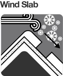
Not a time to be complacent, it’s a complex mix from baseless light powder snow on most aspects through to a developing wind slab on a specific isolated ‘problem’ aspect (see rose below), which is coincidentally the only aspect that holds a base. High Alpine (+1800m) East and South aspects should be treated with caution. Field observations note that the drifting on the south and east alpine aspects has not yet formed into cohesive slabs. The snowpack is right-side-up. Albeit with a dramatic temperature variation from -0.5˚ at the bed surface to -9˚ at air surface across 50cm of new snow. So look for weak layers in the new snow. If the wind picks up today from the west, transportation will take place, creating additional loading on this problem aspect.


Friday 25/09/2020: There is a wind slab avalanche problem developing on aspects lee to the North West and West in the alpine. Importantly here in the North East Vic these specific aspects are the only areas that still held snow up high heading into this storm cycle. As such the only places where enjoyable skiing/riding can likely take place. The snowfall yesterday has created an intermediate interface between the spring isothermal snow and this wind slab making it unclear as to what the bonding with the bed surface is like. So far snowpack is ‘right side up’ but there’s lots more in stall so be sure to your make robust assessments out there good decisions based on these. We bet you are keen to get some, but please don’t let it be your last.
We need your eyes too. If you’ve been touring in the Alpine National Park we’d love to know what you have seen. Every little bit helps.
Weather Summary
Issued: Mon Jul 20
A cold front is crossing southeastern New South Wales this morning, bringing windy conditions to many southern areas, while a new high extends a ridge across the west. This high pressure system will become the dominant synoptic feature for most of the week, as it gradually drifts east across the state, to reach the Tasman Sea by Friday.