MAIN RANGE NSW: RECENT OBSERVATIONS
Updated: 1st september 2017
REPORT CONFIDENCE: MODERATE
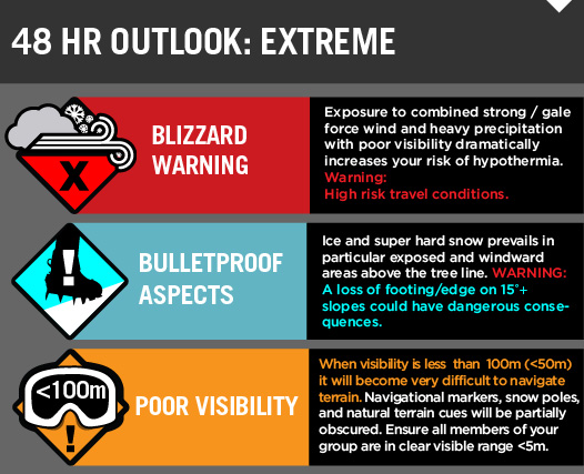
Two fronts that are advancing across the bite are bringing antarctica with them. See the wind chart for elv. 1900m below for the full picture. Anything can happen as we know, and because its lining up over the weekend we have thrown down a few prospective outlooks, yes, forecasts. So that come Sunday afternoon into Monday morning you all well aware that its likely to be 25cm+ of fresh, wind slab, sitting on this persistent boilerplate melt / freeze bed surface. And with that comes an avalanche hazard rating varying between small and likely, through to large and likely slides in all the aspects lee to the North and West. Pretty standard fare. If we get a good lick of rain in the prefrontal then this will go a long way toward increasing the cohesion between the new and old. And back the hazard off to 'Moderate'. Like VIC North East the high ground is a sastrugi bonanza on what will become the loaded slope, so that will also help keep the hazard down until the accumulation tips into the 35cm+ and then its over to you to make the call. Keep you eyes and ears open for warning signs. Good luck and take care, or just enjoy more of the low trees like we have been for the last fortnight.

Hazard Forecast moving into Sunday / Monday:


a rough guide to snow conditions from reports this week
Overall: generally good condition with cover good to excellent in most places. There are still plenty of stashes of dry snow though some areas have developed a bit of a crust. Exposed areas may have been wind stripped resulting in extended patches of ice. Care should be taken when picking a route. Despite the quantity of snow, a lot of creeks remain open.
- Snowy River is open but crossable above Foremans Chimney (some have made their way across on ski’s)
- From Thredbo to Kosciuszko there is less ice than normal and a good cover of packed snow.
- Spencers Creek to Illawong Lodge is skiable and should be nice through the trees.
- You can ski from a few hundred metres past the gate at Munyang all the way to Whites River Hut. Whites and Schlink Huts both have excellent snow cover around them. Either the road or aqueduct can be used to access this area with very minimal walking on the road. Most creeks are open including Valentines River. A few snow bridges on Valentines River near Mawsons but falling in fast. The snow is softening after a crust in the morning and a bit of corn snow developing.
- The track from Porcupine to Betts Creek has been set and there is still a good cover on Johnnies Plain all the way to Charlotte Pass.
- Lower areas such as Plains of Heaven also have a skiable cover of snow.
- Rolling grounds – boiler plate ice
Recent Stability Assessments.


We will fancy this up once we get some spare time.... add 50mm of free water to the top since this observation was taken.


Here is a shot borrowed from instagram from @johnblankenstein of the bottom of Watson's Crags where that top gloop let loose on the melt freeze from the week before. Sounds like a near miss... luckily no casualty. Another party at Blue Lake experienced what sounds like a similar incident however on a north east aspect... so this could be more widespread than we expect.


Check the map for this advisory
Quisque iaculis facilisis lacinia. Mauris euismod pellentesque tellus sit amet mollis.