NORTH EAST VIC
CONDITIONS SUMMARY
UPDATED: 8th AUGUST 2019
REPORT CONFIDENCE: STRONG
CURRENT UNTIL: 10th JuLY 2019
Click to enlarge
IMPORTANT: The following information is provided in good faith. Both the observation and forecasting methods used to provide this summary are not consistent with international standard. They are based in the collective experience of those providing input on the conditions, the hazards and the respective rating if provided. Due to both the spatial and often subjective nature of the observation input available, forecasting is at best an estimate. Understanding, knowledge and practise in self assessment of alpine hazards is crucial to safe backcountry travel in all alpine areas covered here.
CONDITIONS SUMMARY
We have had significant snowfall starting mid morning yesterday. 30 cm or thereabouts. With the preexisting surface conditions observed as icy and slick in places this coupled with a variable temperature gradient in the new snow has created a considerable avalanche hazard as observed by Falls Creek and Mt Hotham Ski Patrol. With more precipitation on its way today this hazard is continuing to build both as windslab on aspects lee to the north through to west to as low as 1600m, and as storm slab on sheltered terrain features at all elevations. The variable bonding with the bed surface and the cohesion within the new snow are the focus of your self assessment practise in the Alpine National Park. Conservative terrain choices are mandatory for safe travel in the alpine today and ongoing. SM


UPDATE 2pm 9/9/2019: With continued precipitation and transportation, whilst below 1800m there’s been no observed natural avalanche events and the observations are consistent with Considerable, beyond 1800m the hazard advances with continued deposition and hence we are issuing High Avalanche Danger Rating regionally for NE Vic Alps. BTW, the weather stations are all down now. Advice based solely off satellite records.
OBSERVED HAZARDS & ACTIVITY
Blizzards conditions forecast. Travel in the backcountry not recommended.
Primary hazard: Considerable Storm stab hazard exists on sheltered aspects at all elevations.
Secondary hazard: Considerable Wind Slab Avalanche Hazard exists on aspect lee to the north through to west, to 1550m.
Tertiary: Where wind scouring has or will occur, a hard ice hazard prevails on windward aspects above 1650m. Be safe out there and enjoy responsibly.

PrIMARY HAZARD: WIND SLAB

SECONDARY HAZARD: STORM SLAB
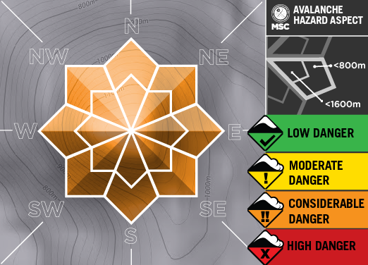
TERTIARY HAZARD

Current Snowpack Conditions
60 cm (100cm+ on drifted wind loaded areas) of fresh variable low to medium density snow (variable -2.5˚) sits on top of nearly isothermal bed surface(-1.5˚ surface, -1˚ snowpack). This surface was observed to be of consistent hardness and quality, and the bonding between the new and old snow may take some time to mend given the difference in the temperature gradient. The variable temperature gradient within the new snow gives rise to concern also. We are mid storm and the process of continued loading over the next 48hrs may begin to overload this bond.
ALPINE WEATHER
Cloudy. Very high (95%) chance of snow showers. The chance of a thunderstorm from late this morning. Gusty winds and possible hail. Winds north to northwesterly 35 to 55 km/h.
CONDITIONS Outlook
IMPROVING / ONGOING / DETERIORATING
Between now and our next update a period of increasing avalanche danger will be occurring. Due to weather and a possible overloading of the bond of new and old snow to a firm bed surface travel in the backcountry is limited to conservative terrain choices. Check in tomorrow morning for more information. . SM

Mount Hotham RESORT
BACKCOUNTRY CONDITIONS:
9th August 2019: Another 27cm overnight accompanied by very strong winds on top of an already sensitive snowpack will make for significant avalanche hazard in the back-country today. It may be harder to trigger in some areas but if it goes it will be damaging. Both wind and storm slabs are present and widespread, so be sure to stick to low angled and densely treed terrain. Take Care. BB


FALLS CREEK RESORT
BACKCOUNTRY CONDITIONS:
8th August 2019: With heavy recent snowfalls and strong winds, in alpine backcountry areas the avalanche hazard is expected to be considerable today. If you travel in alpine backcountry areas today, it’s strongly recommended that you remain in low angled terrain and avoid wind loaded slopes and terrain traps. MO


UPDATE 2pm 9/9/2019: With continued precipitation and transportation, whilst below 1800m there’s been no observed natural avalanche events and the observations are consistent with Considerable, beyond 1800m the hazard advances with continued deposition and hence we are issuing High Avalanche Danger Rating regionally for NE Vic Alps.


