NORTH EAST VIC:
RECENT OBSERVATIONS
UPDATED: 19th / SEPTEMBER /2018
REPORT CONFIDENCE: STRONG
CURRENT UNTIL: 24TH/ SEPTEMBER / 2018
OBSERVATION SUMMARY
TREND: IMPROVING / ONGOING / DETERIORATING
CURRENT OBSERVATION:
With two fresh deposition events over the last 5 days there are pretty varied conditions with soft dry drifted areas and hard windward ice shields with ‘camo snow’ mix of everything in between. Still heaps of snow on all aspects with the exception of mid elevation solar aspects and areas facing the warm winds of last week, again generally the north and west.
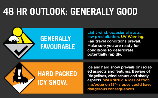
OUTLOOK:
Following the current precip event it looks like we will be headed into more of that rolling freeze thaw cycle.
Sorry about last weeks radio silence on here. We’d been in the field doing research without enough bandwidth to actually make the update. Frustrating when from our position we had line of site to two towers, yet they shoot internet only in the opposite direction.
STABILITY SUMMARY

Primary Hazard


SECONDARY HAZARD

AVALANCHE CHARACTERISTICS

Other Hazards:
Cornice Collapse
With a 2m snowpack (4m on windloaded aspects) we are urging people to be careful and stay well clear of the cornices. The stability of these features has improved over this last week, however with rapid warming or rain they will again become prone to collapse.
Creeks and Gullys
Caution required with creek crossings as transported snow from angles North to South and East have created windlips that encircle and thinly conceal deep wider creek holes.
Weather Models
Snowpack Assessments
The EXTRA Column
The information provided here deviates from the standard reporting format that we apply to the travel advisory. It sometimes shows recent field obs results and images. It is pitched at participants looking for more detail.