NORTH EAST VIC
CONDITIONS SUMMARY
UPDATED: 5th SEPTEMBER 2019
REPORT CONFIDENCE: STRONG
CURRENT UNTIL: 8th SEPTEMBER 2019
Click to enlarge
IMPORTANT: The following information is provided in good faith. Both the observation and forecasting methods used to provide this summary are not consistent with international standard. They are based in the collective experience of those providing input on the conditions, the hazards and the respective rating if provided. Due to both the spatial and often subjective nature of the observation input available, forecasting is at best an estimate. Understanding, knowledge and practise in self assessment of alpine hazards is crucial to safe backcountry travel in all alpine areas covered here.
CONDITIONS SUMMARY
Blizzard Warning Current for next 48hrs.
Observations 5th September 20:00hrs
Take a deep breath, and try to follow this. It’s complex. Right now we have a patchwork of surface conditions. Firstly there is softening of what proved to be a lethal melt freeze and rime crust on most aspects at higher elevations (+1800m). Last Thursdays cold snow (-4 to - 8˚) on this hard crust displayed a variable cover of ‘packed-pow’ (5cm - 30cm) on south and east aspects which has proven to bond well at lower elevations <1750 with the widespread hard crust. At higher elevations this snow was distributed as wind loading on aspects lee to the south and east. Indications are that it too has bonded well now, given several nights of near +/- 0˚ temps (depending on elevation) and some mending of layers as a result.
Academic or practical? Time will tell as a front approaches with a classic ‘spring storm’ vibe. Hopefully prefrontal rain will see the following snow precipitation bond to the hard (yet patchy and hard to define) bed surface. Without rain (at higher elevations) we will see significant wind loading of aspects lee to the north and west. In plain speak we will have windslab (of 30cm, up to 70cm on isolated features) on a slick melt freeze ice crust, which in plain speak points at bad cohesion (and what an offical avy service might describe as ‘high avalanche danger’). At lower elevations (< 1800m) the prevailing front will yield likely windslab characteristics on aspects lee to the north and east between 30cm and 70cm. Storm slab conditions likely <1650m.
This is conjecture based on models, what actually happens (particularly with the wild and unpredictable nature of spring storms mixing warm and cold flows) is yet to be known. We will be back up in this place Saturday morning with an update based on actual observations. Meanwhile, duck for cover as this storm wedges in. Yes, hopefully wet… then cooling to deliver some sweet sweet POWPOW. Right side up… cross your fingers.


OBSERVED HAZARDS & ACTIVITY
Extensive Bulletproof Ice: all aspects from 2000m to 1200m.
PRIMARY HAZARD

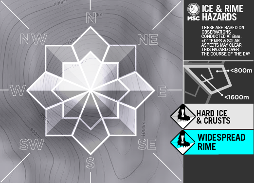
Current Snowpack Conditions
As you’ve seen it is a complex situation with varied surface conditions observed prior to what will be a significant storm. The layers underly the slightly softening yet slick in places, melt/ freeze crust (from ‘key penetration’ to ‘finger’ on solar aspects) whilst ‘persistent’ (moderate to hard results depending on incline) present no hazard given the concrete bridging of the top 5cm.
CONDITIONS Outlook
IMPROVING / ONGOING / DETERIORATING
As a low pressure cell approaches the alps from the bight it will bring with it some prefrontal rain. Passing across the state Friday it then dips into the Tasman and intensifies whipping up a tail end ‘suck’ that will see a further three prolonged bands of precip pass over the state at between -2˚ / 0˚ depending on elevation with snowfalls down to 1000m. These fronts gradually warm with warmer heavier snow expected on the tail fronts from Monday.

Mount Hotham RESORT
BACKCOUNTRY CONDITIONS:


FALLS CREEK RESORT
BACKCOUNTRY CONDITIONS:


FEATHERTOP
ALPINE NATIONAL PARK
BACKCOUNTRY CONDITIONS:

