Kosciusko NP NSW:
RECENT OBSERVATIONS
UPDATED: 4TH / SEPTEMBER /2018
REPORT CONFIDENCE: WEAK
CURRENT UNTIL: 7th / SEPTEMBER / 2018
OBSERVATION SUMMARY
TREND: IMPROVING / ONGOING / DETERIORATING
CURRENT OBSERVATION:
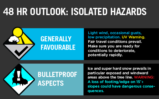
Observations currently indicate that the windward aspects are very hard and wind scoured to the extent that it would seem everything has been blown onto the leeward aspects. As made obvious by the uncharacteristic appearance of those aspects now showing huge wind loading, in places as much as 4m deep. This hard pack, rime and ice is heightened by a cycle of freeze / thaw had started prior to this next deposition (Thursday).
OUTLOOK:
Snow expect to hit the Main Range on Thursday and then back to spring conditions.
The new precip from last week is unlikely to be bonding well to the existing bed surface particularly up high. Steep Wind loaded aspects lee to the West should be avoided.
PRIMARY HAZARD
AVALANCHE PROBLEM: WIND SLAB


SECONDARY HAZARD
ICE & RIME HAZARDS

The EXTRA Column
The information provided here deviates from the standard reporting format that we apply to the travel advisory. It sometimes shows recent field obs results and images. It is pitched at participants looking for more detail.