Click to enlarge
IMPORTANT: The following information is provided in good faith. Both the observation and forecasting methods used to provide this summary are not consistent with international standard. They are based in the collective experience of those providing input on the conditions, the hazards and the respective rating if provided. Due to both the spatial and often subjective nature of the observation input available, forecasting is at best an estimate. Understanding, knowledge and practise in self assessment of alpine hazards is crucial to safe backcountry travel in all alpine areas covered here.
MAIN RANGE NSW:
RECENT OBSERVATIONS
UPDATED: 6th SEPTEMBER 2019
REPORT CONFIDENCE: WEAK
CURRENT UNTIL: 10TH SEPTEMBER 2019
CONDITIONS SUMMARY
Since the previous update the observations have been patchy. in part due to the fact that almost the entire backcountry industry has left the state, we believe with the exception of Doug and Jeff at SMBC and K2 respectively. It might pay to chase them down. What we do know is that theres been two precipitation events. Thursday last week with 10-20cm of cold dry snow which bonded poorly to the steeper aspects lee to the west. This was sitting on a very hard and slick bed surface of melt freeze crust.
Thursday this week we’ve seen a ‘top-up’ of wet high density snow and drizzle. Given that this combined with the poor cohesion from what would be considered a persistent weak layer at the interface of the older precip and the crust below there’s reason to be cautious (higher up >1900m) on steep aspects lee to the north and west and expect easy sloughing off from that wet layer (very small but likely).
Another big storm due to land shortly, with big precip figures, starting as rain and ending up with something between 15-25cm deposition (30-70cm on windloaded aspects lee to the north and west). With scanty intel and few observations self assesment of the snowpack and potential for wind slab and storm slab avalanche will be crucial for safe travel in the backcountry.
If you have seen anything let us know. Cheers.
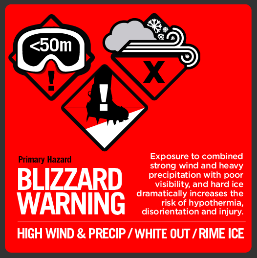
OBSERVED HAZARDS & ACTIVITY
• Blizzard conditions
• Extensive hard ice prevails at all altitudes and all aspects.
CURRENT SNOWPACK CONDITIONS


ALPINE WEATHER
Wet precip turning to snow mid afternoon today and contiuning with an increase in wind to 60km over the next 48hrs. Take care out there.
CONDITIONS Outlook
IMPROVING / ONGOING / DETERIORATING

Scheduled Observations

MT TATE & GUTHEGA TRIG AREA
BACKCOUNTRY CONDITIONs:
NA


