CENTRAL EAST VIC:
RECENT OBSERVATIONS
Updated: 30TH / JULY /2018
REPORT CONFIDENCE: STRONG
CURRENT UNTIL: 2ND / AUGUST/ 2018
OBSERVATION SUMMARY
TREND: IMPROVING / ONGOING / DETERIORATING
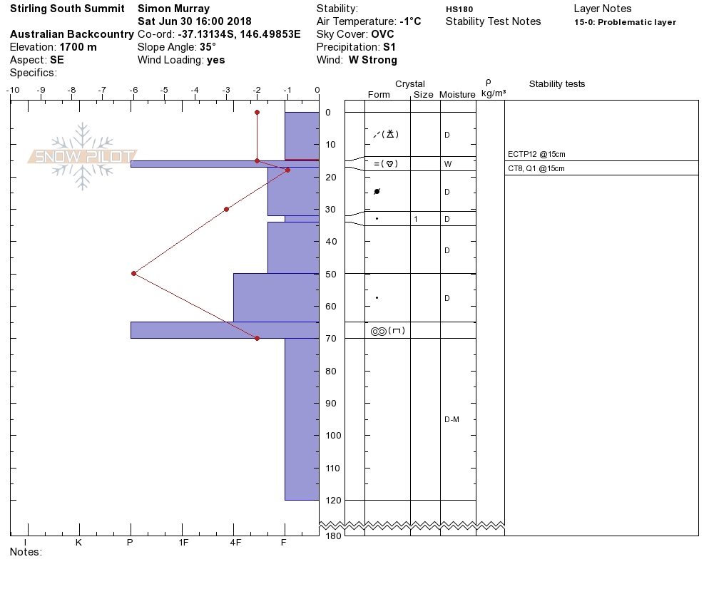
Front Range: Buller / Stirling
From what was becoming a pretty miserable breakable crust on top of rain effected mush, we had a good refreeze and now the new snow that settled is supportive and will be fun for touring off piste. Fast and dry.
BACK Range: Magdala / Howitt / Viking & Cobbler
The rain effected snow would ordinarily bonding really well to the new snow, yet what we observed came in as large dry rounds, smoothing out any surface cohesion with a layer of ball bearings effectively. Thus priming the bed surface on leeward wind slab aspects to slide. To compound this the centre of the hazard arc is lee to the west, which makes most of the steep terrain north of Mount Howitt super primed. Mindful also of the objective hazard of the terrain traps in this region, moderate is really considerable with regards t consequence in the event something pulls out. So We are on moderate warning for the range spanning Cobbler to Magdala for the duration of this next precipitation cycle, not due to conclude really until our next update on Thursday and even into Friday.
ExTENDED OUTLOOK
There are three big fronts Tuesday, Friday and Sunday. This is Mid winter conditions, and if any of these roll in with 15cm 'On the stakes', then everyone needs to be making smart decisions on terrain choice because, 15cm on the stakes is 40cm on the drift (and more on the cornice), and a 40cm crown wall that propagates 20mx20m is enough to end your day. Stay vigilant folks...
Always, a big thanks to everyone who is helping make this possible through our membership kickstart and through our merchandise drive.

Front Range


Sure, there is a chance that the leeward aspects will slide, that said 'Large and Possible' is generally reported as a 'Considerable' avalanche problem, however we know from our observations that the front range generally enjoys an even distribution pattern so 'Large' is not as big as what we see further north. Not playing this down because this could 'possibly' bury you.